Fájl:Sarajevo Grbavica.JPG
 Az előnézet mérete: További felbontások: | | | | .
Eredeti fájl (2 900 × 1 860 képpont, fájlméret: 3,9 MB, MIME-típus: image/jpeg)
|
Ez a fájl a Wikimedia Commonsból származik. Az alább látható leírás az ottani dokumentációjának másolata. A Commons projekt szabad licencű kép- és multimédiatár. Segíts te is az építésében! |
Összefoglaló
| LeírásSarajevo Grbavica.JPG |
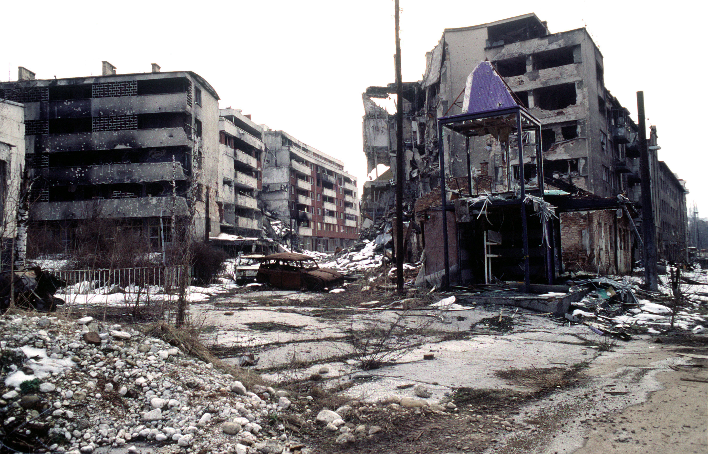
View of Grbavica, a neighbourhood of Sarajevo, approximately 4 months after the signing of the Dayton Peace Accord that officially ended the war in Bosnia. This particular scene shows the part of the neighbourhood located by the left bank of Miljacka river near Vrbanja bridge at the point where Zagrebačka Street and Beogradska Street (later renamed Emerika Bluma Street) meet. Throughout the war (1992-1995), Grbavica was held by the forces of Bosnian Serbs. In relation to the part of Grbavica shown in the photo, Bosnian Muslim (Bosniak) lines were right across on the Miljacka river's right bank. Due to its location in the crossfire between two sides, this part of Grbavica was exposed to constant fire and as a result suffered heavy structural damage. It was basically uninhabitable throughout the war - most of the apartments in the buildings seen in the photo were empty during the war as their occupants fled early on fearing for their safety. These ruins of the apartments and houses were among the last group to be turned over by the Bosnian Serbs to the Bosniaks (a.k.a. Bosnian Muslims) as required by the Dayton Peace Accord, which produced a lasting cease fire and permanent internal borders between two entities - Republika Srpska (Serb entity) and Federation of Bosnia-Herzegovina (Muslim-Croat entity). The white building whose small part (corner) can be seen along the photo's left edge housed the state-owned Unioninvest company before the war. In the years after the war ended, the partially devastated building was rebuilt and to this day houses the Office of the High Representative (OHR), an ad hoc international institution responsible for overseeing implementation of the Dayton Peace Accord (in essence, OHR is Bosnia's highest decision-making institutional body with broad powers). |
| Dátum | 1996. március 9. |
| Forrás | www.dodmedia.osd.mil |
| Szerző | LT. STACEY WYZKOWSKI |
| Engedély (Fájl újrafelhasználása) |
Public Domain (PD-USGov-Military) |
Licenc
| Ez a fotó vagy kép az USA hadserege vagy védelmi minisztériuma alkalmazottjának hivatalos feladatai során készült. Mint az USA szövetségi kormányának munkája, a kép közkincsnek számít.
|

|
Képaláírások
magyarAdj meg egy egysoros magyarázatot arról, hogy mit mutat be ez a fájlA fájl által ábrázolt elemek
mű tárgyakulcseseménySzarajevó ostromaszerzői jogi állapotközkincslétrejöttének ideje9. március 1996nézőpont koordinátái43°51'10.148"N, 18°24'20.070"Eheading angol: 225 fokFájltörténet
Kattints egy időpontra, hogy a fájl akkori állapotát láthasd.
| Dátum/idő | Bélyegkép | Felbontás | Feltöltő | Megjegyzés | |
|---|---|---|---|---|---|
| aktuális | 2009. április 7., 23:02 | | 2 900 × 1 860 (3,9 MB) | PRODUCER | contrast |
| 2008. március 23., 16:37 |  | 2 900 × 1 860 (2,14 MB) | ¡0-8-15! | ||
| 2006. november 21., 00:00 |  | 640 × 410 (60 KB) | Bunker~commonswiki | == Summary == {{Information |Description=Overall view of downtown Grbavica, a suburb of Sarajevo. These apartments and houses once occupied by Bosnia Serbs are the last group to be turned over to the Muslims as required by the recent Dayton Peace Accord w |
Fájlhasználat
Az alábbi lapok használják ezt a fájlt:
Globális fájlhasználat
A következő wikik használják ezt a fájlt:
- Használata itt: als.wikipedia.org
- Használata itt: ar.wikipedia.org
- Használata itt: azb.wikipedia.org
- Használata itt: be.wikipedia.org
- Használata itt: bg.wikipedia.org
- Használata itt: bs.wikipedia.org
- Használata itt: ca.wikipedia.org
- Használata itt: cs.wikipedia.org
- Használata itt: de.wikipedia.org
- Használata itt: el.wikipedia.org
- Használata itt: en.wikipedia.org
- Használata itt: en.wikinews.org
- Használata itt: en.wikiquote.org
- Használata itt: eo.wikipedia.org
- Használata itt: es.wikipedia.org
- Használata itt: eu.wikipedia.org
- Használata itt: fa.wikipedia.org
- Használata itt: fr.wikipedia.org
- Használata itt: he.wikipedia.org
- Használata itt: hr.wikipedia.org
- Használata itt: id.wikipedia.org
- Használata itt: it.wikipedia.org
A fájl globális használatának megtekintése
Metaadatok
Ez a kép járulékos adatokat tartalmaz, amelyek feltehetően a kép létrehozásához használt digitális fényképezőgép vagy lapolvasó beállításairól adnak tájékoztatást. Ha a képet az eredetihez képest módosították, ezen adatok eltérhetnek a kép tényleges jellemzőitől.
| Tájolás | Normál |
|---|---|
| Vízszintes felbontás | 72 dpi |
| Függőleges felbontás | 72 dpi |
| Használt szoftver | Adobe Photoshop CS4 (11.0x20071101 ) Windows |
| Utolsó változtatás ideje | 2009. április 7., 17:01 |
| Színtér | sRGB |
| Képszélesség | 2 900 px |
| Képmagasság | 1 860 px |
| Digitalizálás dátuma és időpontja | 2009. április 7., 13:01 |
| Dátum metaadat utolsó módosítása | 2009. április 7., 13:01 |